
 Italiano
Flying area
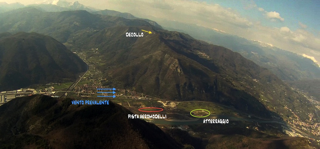
| Take off 43°58’39.36″N 10°30’13.32″E altitude: 720m s.l.m. | Landing 43°58’5″N 10°31’22″E altitude: 52 s.l.m. |
ATTERRAGGIO
TAKE OFF
From the landing site go back to the main road and follow direction “Borgo a Mozzano” (right turn).
Take left at the first crossing direction “Cune” first, and follow Monte Bargilio right after. Once reached the end of the paved road keep same direction for few hundred meters (on unpaved) until you reach a clearing and you see the sign “Decollo” on your left hand. Park the car and walk the trail for approximately 10 minutes. Wintertime can be tricky and the road may be icy: be careful therefore.
Take off face south and wind breeze is often rightly orientated even when the area is affected by slight or moderate North wind, granting fliable conditions even when it is not possible elsewhere in the region.
Take off area is wide but rocky. Although some carpets have been recently added (visible from the main road -SP 2 Ludovica- down the valley) be particularly careful to paraglider lines.
To end with, the wind here is often fast. Local pilots are skilled with face wing take off . Be sure to master this technique adequately.
TOP LANDING
Wind strength and passing by thermics may generate turbulence, gusts and rotors.
Top landing is feasible by skilled pilots only therefore.
CAUTION
Do not fly above the model aircraft area (shown in red on the map). This site may be used for emergency landing only.
Launch area is wild: bores hunters are often in the near-by during wintertime and don’t forget to take all of your rubbish with you.
Drive slowly in Cune as kids are often around and local residents takes their serenity into great consideration.